I’ve had a theory for some time now. Whoever named a lot of towns in the Western districts of Victoria liked the letter “C.” I have no idea why or how it happened but there are quite a number of them – Colac, Ceres, Coleraine, Cape Otway, Carlisle River, Connewarre, Cathcart, Cavendish, etc. You get my point.
My next book is close to being ready but in order to get it finalised I have a lot of facts to check and unfortunately for me that last 20% really takes more than 80%.... One of the tasks I have is to check out a few towns and places west of Geelong. There’s a little town in the region that time forgot. It’s called Cressy. It’s 65 km west of Geelong, straight out the Hamilton Highway. I’ve trying to figure how and why I’ve missed going there to date. This week I found out why. It’s not quite on the highway and, today, there’s very little there that will draw you in.
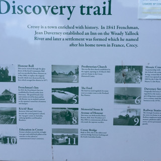
The reason I was interested in Cressy goes back to a previous post. There’s a ford and a hotel (formerly an inn) there and the subject of my book used both of these quite a lot. Cressy was once on the well worn path that the squatters and pastoralists took to go west to what was known as the “Portland Bay District.” At Cressy there was a ford across the Woady Yalloak (or sometimes Yallock) River. Here, a smart Frenchman named Fred Duverney built an inn in 1839 and obtained a license for it in 1841. It was known as Frenchman’s Inn and it stood on his run there, Frenchman’s run. The inn stood alongside the ford for all the travellers to stay and refresh at.
Unsurprisingly, Duverney is responsible for naming the town Cressy, which was named for Crecy in France where he was born. The inn is still there, though it’s been closed for some time now, apparently circa 2008. It’s partly a post office and mostly just boarded up.
The main street, Duverney Street, is a trip back in time. There are no longer any shops but you can see where they once were. The produce store look like it was fantastic. The other main street in Cressy is Tennant Street. Named for Robert Tennent (notice the spelling error) who once held the nearby Gnarkeet station with his friend Charles Hugh Lyon. He has a street in Cressy named after him as well.
Now other than being a fairly successful pastoralist Mr Tennent was a pretty smart cookie and managed to take one of the first photographs ever recorded in Australia. As a member of the Edinburgh Calotype Club he is famous for his photograph “Kitchen Hut Gnarkeet Station, Port Phillip” apparently taken in April 1848 with a camera made out of a cigar box and the lens from a telescope.
Like a lot of country towns, Cressy has a historical society and they have put up signs and markers for the main points of attention. In addition to what I’ve already covered, there’s the former RAAF base, the former train station, a church and the bridge, which duly replaced the ford.
The RAAF base was news to me. The plaque explains that between 1939 and 1946 the Royal Australian Air Force operated a combat training aerodrome in Cressy, originally the #1 armament training station. Between 1942 and 1943 a general reconnaissance school was incorporated with the course including submarine searching, ship spotting and recognition. Between 1944 and 1945 Cressy became the central gunnery school, the “top gun” course in Australia, utilizing Spitfires and Beaufort Bombers.
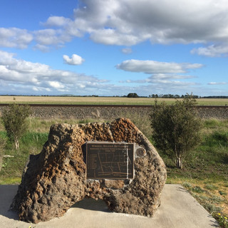
My task complete in Cressy I headed back to Geelong. On the way home two things caught my eye. The first, on the side of the highway about 10 kms out of Cressy was a plaque commemorating the “Wingeel Soldier Settlement.” A soldier settlement refers to the settlement of land throughout parts of Australia by returning discharged soldiers under schemes administered by the state governments after World Wars I and II. The Discharged Soldier Settlement Act 1917 provided for settlement of the returned soldiers under the same general conditions as closer settlement had except that here they were more generous. Principally this related to the lack of capital as not being a deterrent for soldiers in obtaining land.
There are quite a number of these settlements in the region that I’ve seen before including ones at Drysdale (on the Bellarine Peninsula) and in Warrambine, near Shelford.
Further down the road and just 28 kms out of Geelong I arrived into Inverleigh a regular haunt for me lately. Here, tucked away near the war memorial on the highway I found the same thing that I wrote about in my previous post about the Bellarine rail trail. Sponsored by Legacy, they also have an Aleppo pine, a descendant of the original lone pine from Gallipoli. There’s really something about country towns that you just have to love and respect.
Take a good look when you’re out and about – you never know what you’ll find!
Until next time, have fun out there.
Chris


